|
| Narragansett Bay Water Quality Monitoring Network |
| Bay fixed-site monitoring data are provided by the cooperative efforts
of the RI Department of Environmental Management Water
Resources Division, the Narragansett
Bay National Estuarine Research Reserve, the Narragansett
Bay Commission, the URI Graduate School
of Oceanography, Roger Williams University,
and the Bay Window Program.
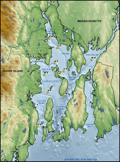
Buoys were equipped with two sondes that measured temperature, salinity, dissolved oxygen and depth at approximately 1 meter from the bottom and 0.5 meters below the surface. In addition, chlorophyll fluorescence was measured by the near surface sonde. Measurements were collected at fifteen minute intervals and transmitted to shore via cellular modems every eight hours or via radio signal every fifteen minutes. The instruments were serviced every two weeks to minimize biofouling. Additional Data Sources and Information: Recent Publications:
|
 |
| Daily Average Data | |||
| The following data files represent daily averages calculated from raw 15 minute recorded data. These data are preliminary; they are subject to corrections after post-deployment re-calibration of sensors. Users are expected to cite the appropriate source for the data and meet any wishes of the researchers listed in the "header" or "notes" sections of the data files. | |||
| Year | Dates | Location | Data File |
| 1999 | 1 July - 31 December | N. Prudence (NP) | NP_1999_dailyave |
| 2001 | 7 May - 27 December | Bullock Reach (BR) | BR_2001_dailyave |
| 29 June - 27 December | N. Prudence (NP) | NP_2001_dailyave | |
| 2002 | 7 June - 31 December | Bullock Reach (BR) | BR_2002_dailyave |
| 14 June - 31 December | N. Prudence (NP) | NP_2002_dailyave | |
| 2003 | 23 May - 5 October | Bullock Reach (BR) | BR_2003_dailyave |
| 6 June - 29 September | Conimicut Point (CP) | CP_2003_dailyave | |
| 26 June - 26 September | Greenwich Bay (GB) | GB_2003_dailyave | |
| 6 June - 6 October | N. Prudence (NP) | NP_2003_dailyave | |
| 2004 | 1 June - 30 September | Bullock Reach (BR) | BR_2004_dailyave |
| 2 June - 12 October | Mount View (MV) | MV_2004_dailyave | |
| 4 June - 28 September | N. Prudence (NP) | NP_2004_dailyave | |
| 30 June - 12 July | Phillipsdale (PD) | PD_2004_dailyave | |
| 8 July - 12 October | Popasquash Point (PP) | PP_2004_dailyave | |
| 2005 | 1 June - 31 October | Bullock Reach (BR) | BR_2005_dailyave |
| 1 June - 21 October | Conimicut Point (CP) | CP_2005_dailyave | |
| 8 June - 8 December | Greenwich Bay (GB) | GB_2005_dailyave | |
| 29 June - 9 November | Mount Hope Bay (MH) | MH_2005_dailyave | |
| 1 June - 21 October | Mount View (MV) | MV_2005_dailyave | |
| 23 May - 21 October | N. Prudence (NP) | NP_2005_dailyave | |
| 1 January - 21 December | Potters Cove (PC) | PC_2005_dailyave | |
| 13 April - 14 December | Phillipsdale (PD) | PD_2005_dailyave | |
| 20 July - 9 November | Popasquash Point (PP) | PP_2005_dailyave | |
| 29 July - 21 October | Quonset Point (QP) | QP_2005_dailyave | |
| 1 January - 31 December | T-Wharf, Prudence Is. (TW) | TW_2005_dailyave | |
| 2006 | 2 June - 31 October | Bullock Reach (BR) | BR_2006_dailyave |
| 18 May - 31 October | Conimicut Point (CP) | CP_2006_dailyave | |
| 23 March - 31 December | Greenwich Bay (GB) | GB_2006_dailyave | |
| 19 May - 31 October | Mount Hope Bay | MH_2006_dailyave | |
| 18 May - 31 October | Mount View (MV) | MV_2006_dailyave | |
| 18 May - 31 October | N. Prudence (NP) | NP_2006_dailyave | |
| 26 April - 31 December | Phillipsdale (PD) | PD_2006_dailyave | |
| 18 May - 31 October | Popasquash Point (PP) | PP_2006_dailyave | |
| 19 May - 31 October | Quonset Point (QP) | QP_2006_dailyave | |
| 1 January - 31 December | T-Wharf, Prudence Is. (TW) | TW_2006_dailyave | |
| 2007 | |||
| 24 May - 5 December | Bullock Reach (BR) | BR_2007_dailyave | |
| 25 May - 31 October | Conimicut Point (CP) | CP_2007_dailyave | |
| 1 January - 31 December | Greenwich Bay (GB) | GB_2007_dailyave | |
| 26 May - 31 October | Mount Hope Bay (MH) | MH_2007_dailyave | |
| 25 May - 31 October | Mount View (MV) | MV_2007_dailyave | |
| 26 May - 31 October | N. Prudence (NP) | NP_2007_dailyave | |
| 1 January - 31 December | Phillipsdale (PD) | PD_2007_dailyave | |
| 26 May - 31 October | Popasquash Point (PP) | PP_2007_dailyave | |
| 19 June - 31 October | Quonset Point (QP) | QP_2007_dailyave | |
| 1 January - 31 December | T-Wharf, Prudence Is. (TW) | TW_2007_dailyave | |
| 2008 | |||
| 8 May - 9 November | Bullock Reach (BR) | BR_2008_dailyave | |
| 21 May - 3 November | Conimicut Point (CP) | CP_2008_dailyave | |
| 1 January - 31 December | Greenwich Bay (GB) | GB_2008_dailyave | |
| 10 June - 31 October | Mount Hope (MH) | MH_2008_dailyave | |
| 14 May - 2 November | Mount View (MV) | MV_2008_dailyave | |
| 20 May - 2 November | N. Prudence (NP) | NP_2008_dailyave | |
| 1 April - 22 December | Phillipsdale (PD) | PD_2008_dailyave | |
| 20 May - 31 October | Popasquash Point (PP) | PP_2008_dailyave | |
| 20 May - 31 October | Quonset Point (QP) | QP_2008_dailyave | |
| 14 May - 4 November | Sally Rock (SR) | SR_2008_dailyave | |
| 1 January - 31 December | T-Wharf, Prudence Is. (TW) | TW_2008_dailyave | |
| 2009 | |||
| 1 June - 28 October | Bullock Reach (BR) | BR_2009_dailyave | |
| 11 May - 26 October | Conimicut Point (CP) | CP_2009_dailyave | |
| 1 January - 31 December | Greenwich Bay (GB) | GB_2009_dailyave | |
| 3 June - 14 October | Mount Hope Bay (MH) | MH_2009_dailyave | |
| 27 May - 26 October | Mount View (MV) | MV_2009_dailyave | |
| 27 May - 26 October | N. Prudence (NP) | NP_2009_dailyave | |
| 7 April - 13 December | Phillipsdale (PD) | PD_2009_dailyave | |
| 27 May - 26 October | Popasquash Point (PP) | PP_2009_dailyave | |
| 27 May - 26 October | Quonset Point (QP) | QP_2009_dailyave | |
| 13 May - 3 November | Sally Rock (SR) | SR_2009_dailyave | |
| 1 January - 31 December | T-Wharf, Prudence Is. (TW) | TW_2009_dailyave | |
| 9 December 08 - 21 May | Upper Bay, Winter Station (UB) | UB_2009_dailyave | |
| 2010 | |||
| 7 June - 30 September | Bullock Reach (BR) | BR_2010_dailyave | |
| 28 May - 3 November | Conimicut Point (CP) | CP_2010_dailyave | |
| 1 January - 30 September | Greenwich Bay (GB) | GB_2010_dailyave | |
| 1 January - 31 December | GSO Dock (GD) | GD_2010_dailyave | |
| 30 May - 3 November | Mount Hope Bay (MH) | MH_2010_dailyave | |
| 28 May - 26 October | Mount View (MV) | MV_2010_dailyave | |
| 28 May - 1 November | N. Prudence (NP) | NP_2010_dailyave | |
| 28 May - 3 November | Popasquash Point (PP) | PP_2010_dailyave | |
| 28 May - 1 November | Quonset Point (QP) | QP_2010_dailyave | |
| 9 June - 3 November | Sally Rock (SR) | SR_2010_dailyave | |
| 21 October 09 - 30 April | Upper Bay, Winter Station (UB) | UB_2010_dailyave | |
| 2011 | |||
| 6 June - 8 November | Bullock Reach (BR) | BR_2011_dailyave | |
| 27 May - 3 November | Conimicut Point (CP) | CP_2011_dailyave | |
| 1 January - 31 December | Greenwich Bay (GB) | GB_2011_dailyave | |
| 1 January - 31 December | GSO Dock (GD) | GD_2011_dailyave | |
| 27 May - 3 November | Mount Hope Bay (MH) | MH_2011_dailyave | |
| 25 May - 3 November | Mount View (MV) | MV_2011_dailyave | |
| 27 May - 3 November | N. Prudence (NP) | NP_2011_dailyave | |
| 29 March - 31 December | Phillipsdale (PD) | PD_2011_dailyave | |
| 27 May - 3 November | Popasquash Point (PP) | PP_2011_dailyave | |
| 25 May - 3 November | Quonset Point (QP) | QP_2011_dailyave | |
| 25 May - 3 November | Sally Rock (SR) | SR_2011_dailyave | |
| 1 January - 31 December | T-Wharf, Prudence Is. (TW) | SR_2011_dailyave | |
| 25 October 10 - 6 June | Upper Bay, Winter Station (UB) | UB_2011_dailyave | |
| 2012 | |||
| 17 May - 3 October | Bullock Reach (BR) | BR_2012_dailyave | |
| 21 May - 27 October | Conimicut Point (CP) | CP_2012_dailyave | |
| 1 January - 31 December | GSO Dock (GD) | GD_2012_dailyave | |
| 21 May - 27 October | Mount Hope Bay (MH) | MH_2012_dailyave | |
| 21 May - 27 October | Mount View (MV) | MV_2012_dailyave | |
| 21 May - 27 October | N. Prudence (NP) | NP_2012_dailyave | |
| 21 May - 27 October | Popasquash Point (PP) | PP_2012_dailyave | |
| 21 May - 27 October | Quonset Point (QP) | QP_2012_dailyave | |
| 24 May - 27 October | Sally Rock (SR) | SR_2012_dailyave | |
| 18 October 11 - 24 May | Upper Bay, Winter Station (UB) | UB_2012_dailyave | |
| 2013 | |||
| 14 May - 17 October | Bullock Reach (BR) | BR_2013_dailyave | |
| 14 May - 22 October | Conimicut Point (CP) | CP_2013_dailyave | |
| 1 May - 1 October | Greenwich Bay (GB) | GB_2013_dailyave | |
| 1 January - 29 July | GSO Dock (GD) | GD_2013_dailyave | |
| 14 May - 17 October | Mount Hope Bay (MH) | MH_2013_dailyave | |
| 14 May - 17 October | Mount View (MV) | MV_2013_dailyave | |
| 14 May - 17 October | N. Prudence (NP) | NP_2013_dailyave | |
| 14 May - 17 October | Popasquash Point (PP) | PP_2013_dailyave | |
| 14 May - 17 October | Quonset Point (QP) | QP_2013_dailyave | |
| 14 May - 17 October | Sally Rock (SR) | SR_2013_dailyave | |
| 2014 | |||
| 21 May - 25 October | Bullock Reach (BR) | BR_2014_dailyave | |
| 21 May - 10 October | Conimicut Point (CP) | CP_2014_dailyave | |
| 21 May - 30 September | Mount View (MV) | MV_2014_dailyave | |
| 21 May - 15 September | N. Prudence (NP) | NP_2014_dailyave | |
| 21 May - 05 November | Popasquash Point (PP) | PP_2014_dailyave | |
| 21 May - 16 September | Quonset Point (QP) | QP_2014_dailyave | |
| 21 May - 28 August | Sally Rock (SR) | SR_2014_dailyave | |
| 13 January - 24 February | Upper Bay, Winter Station (UB) | UB_2014_dailyave | |
| 2015 | |||
| 3 June - 4 November | Bullock Reach (BR) | BR_2015_dailyave | |
| 28 May - 4 November | Conimicut Point (CP) | CP_2015_dailyave | |
| 28 May - 4 November | Mount Hope Bay (MH) | MH_2015_dailyave | |
| 28 May - 5 November | Mount View (MV) | MV_2015_dailyave | |
| 28 May - 4 November | N. Prudence (NP) | NP_2015_dailyave | |
| 28 May - 4 November | Popasquash Point (PP) | PP_2015_dailyave | |
| 28 May - 28 October | Quonset Point (QP) | QP_2015_dailyave | |
| 1 January - 31 December | T-Warf,Prudence Is. (TW) | TW_2015_dailyave | |
| 28 October - 14 May | Upper Bay,Winter Station (UB) | UB_2015_dailyave | |
| 2016 | |||
| 22 October - 8 March | Upper Bay, Winter Station (UB) | UB_2016_dailyave | |
| Multi-Year Data | ||
| Year(s) | Location | Data File |
| 1995 - 2010 | GSO Pier (GD) | GD_95-10 |
| Discontinued Sampling Stations | ||
| Year(s) | Location | Data File |
| 2005 | Ft. Wetherall | FW_2005 |
| 2000 - 2001 | Pomham Rocks (PR) | PR_00-01 |
| 1999 | S. Prudence (SP) | SP_1999 |
| 2001 | SP_2001 | |
| 2002 | SP_2002 | |
| Copyright 2005 | Narrbay |