
|
OceanSAMP Tier 1 Analysis Maps |
|||
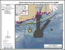 |
Tier 1: Exclusion Criteria Areas within the SAMP study area that would be excluded from development based on existing, non-compatible uses. |

|
|
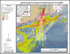 |
Tier 1: AIS Vessel Counts A 1km grid displaying AIS vessel counts between 9/2007 and 7/2008. Used to show actual vessel movement patterns. |
||
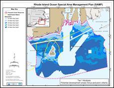 |
Tier 1: Developable Bathymetry Areas that could potentially be open for development after removal of the exclusion criteria. |
||
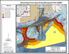 |
Tier 1: Visualization Areas that are potentially open to development that are more than 8, 10, 12, 15, and 20km from land. |
||


